Spanish French German Italian Portuguese Arabic Japanese Korean Chinese Russian
RSS | Bookmark
Earn $$ with WidgetBucks!

Tuesday, June 19, 2007

Mt. Stong - 4,701 ft.

The rugged landscape of Kelantan’s interiors offers many exciting adventures for anyone who loves the great outdoors. From limestone hills to rushing rapids, from thick tropical jungles to cool cavernous caves, Kelantan is a pleasure to experience.
The best way to enter the interiors of Kelantan and, at the same time, get a first-hand look at the typical village life, is to take the KTM train – once romantically known as the Jungle Train in the spirit of adventure and exploration – right through the state. One of the stops along the way is in the quaint village of Dabong, about 155 kilometers from Kota Bharu, the state capital. Dabong lies in the area dedicated as Mt.Stong State Park (formerly called Jelawang Jungle) and is situated on the fringes of Malaysia’s massive Titiwangsa range.

The mountainous backdrop there is made up of a chain of majestic peaks, waiting to be conquered – Gunung Ayam, Gunung Stong, Gunung Tera, Gunung Saji, Gunung Koh, Gunung Baha, Gunung Beirut, Gunung Che Tahir. (Gunung is the local word for mountain). One of the main attractions at the state park is Gunung Stong (1,422 meters), a dome-shaped granite complex more than 500 million years old. Here, the seven-tiered Stong Waterfalls, reputed to be the highest in Southeast Asia, drops from a height of about 990 metres. Reaching the peak of the falls takes two hours of trekking for about one kilometer on steep inclines of between 60 to 90 degrees.

The Mt.Stong State Park is listed among the top five unique ecotourism destinations in Malaysia. It covers an area of 21,950 hectares of land dotted with high peaks, dense forest, a variety of caves, rivers and waterfalls. Its thick jungle is home to elephants, tigers, bears, gibbons, hornbills and a range of other exotic wildlife, as well as a variety of flora and fauna including the world’s largest flower, the rafflesia of the kerii meyer species, and the endemic long-sectioned bamboo, a type of purple herb (Didymocarpus calcareous) and a unique palm species (Licuala stongesis).

With the assistance of a qualified and knowledgeable trekking guide, the journey uphill is made more meaningful as he points out species of wildlife sighted along the way. In good weather conditions, an experienced guide can take travelers along the scenic route of the waterfalls from the foot of Gunung Stong at least halfway before continuing inland for the rest of the hike up. This route showcases the waterfall cascading down from great heights along the solid granite rock structure, a breath-taking sight to behold.


At the peak of Stong Waterfalls is Baha’s Camp – and much-appreciated rest for tired legs. Weary travellers often make Baha’s Camp their pit stop for the night before continuing up Gunung Stong the following day. It has eight wooden huts and two camping grounds that can accommodate between 200 and 300 people at one time. From here, one can sit at the edge of smooth, large rocks and watch the crystal-clear waters of Stong river rush down over the steep edge of the mountain. In the mornings, a thick fog floats in the air creating the dreamy effect of walking on clouds. By noon, the fog clears to reveal a magical view of the lush green valley below. When night descends, snuggle up by the campfire as the mysterious legends and folklores about the origins of Gunung Stong are unraveled.

From Baha’s Camp, it only takes a minute to walk over to the Kolam Tuan Puteri (Princess Pool) where one can enjoy a refreshing dip by the falls. About 25 minutes trek from Baha’s Camp is the Telaga Tujuh (Seven Wells), a series of smaller waterfalls that empty into mini pools.


Photobucket Photobucket


Other places worth visiting and easily accessible from Baha’s Camp are:
  1. The Y Waterfalls, also known as the Last Waterfalls, where separate waterfalls from two mountains, Gunung Stong and Gunung Ayam, meet. Legends abound that it is the proverbial fountain of youth as those who drink from it are said to retain a youthful appearance ( 30 minutes away from Baha's Camp).
  2. Sungai Rantai @ Check Point One (1) to Mt.Stong & Mt.Ayam :- can be reach after 60-90 minutes walked.
  3. Benta Balak @ Check Point Two (2) to Mt.Stong & Mt.Ayam :- suitable for bird watching & camping. 60-90 minutes away from Sungai Rantai.
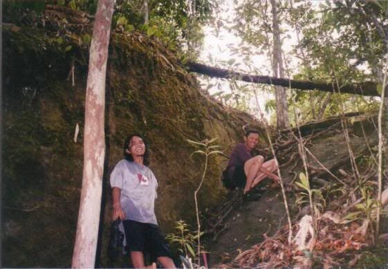
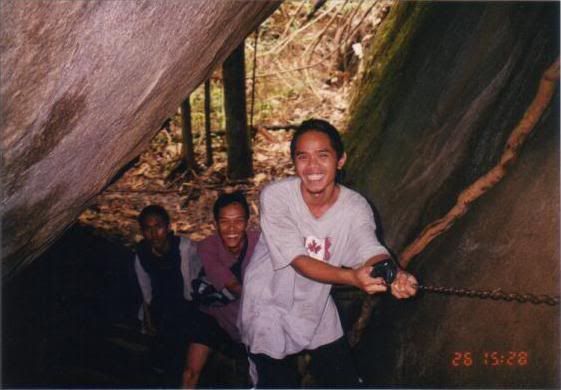
  4. Bogor Caves @ Check Point Three (3) to Mt.Stong :- a cave-like formation by two huge boulders and a suitable resting point for the night on the way to the peak of Gunung Stong. River & nature pool just next to the cave. 30-45 minutes from Benta Balak.
  5. Sungai Baha @ Check Point Three (3) to Mt.Ayam :- suitable for resting point (lunch) before climb up to Mt.Ayam peak. 60-90 minutes from Benta Balak.
  6. The summit of Gunung Stong (Mt.Stong), which can be reached within two (2) hours of trekking from Bogor Caves.
  7. Gunung Ayam (Mt.Ayam), the highest peak in the area, standing at 1,504 metres needs about six hours of trekking to reach its peak. It is the ideal spot to watch both sunset and sunrise. A campsite is available for overnight stays.Kelantan, cloaked in dense jungles, high peaks, mysterious caves, swirling rapids and shrouded in mystery and folklore, hides the promise of romantic and thrilling adventures that will test your endurance, push your physical and mental limits, and simply take your breath away. It is an off-the-beaten destination that few travelers venture to but one that will definitely make you return for more.

Tuesday, June 12, 2007

Mt. Bubu - 5,144 ft

Height: 1568 m (5,144 ft)
Location: Kuala Kangsar, Perak

Foot: Hutan Lipur Ulu Kenas, Perak
Duration : 4 days

Expedition type: Midweight Backpacking
Suggested Rucsac Capacity: 50 liters
Estimated Rucsac Loading: 12-16 kg

Water Supply: 2 days without water.
Suggested water carrier: 4.5 liter per person

Summit temperature: 5-15 deg Celcius


Gunung Bubu has its fair share of legend and myths. This 1,568m mountain is found in Kuala Kangsar and its peak can be rather cold. Charting temperatures of about 5 to 15 degrees Celsius at the summit, this mountain is for the fit and healthy only. There is a pool of water found at its summit that is a common water source for hikers and mountaineers. It is believed that during long lost time, a man throw a bubu (gadget to capture fish) from his village to the summit. As a result, a pond is created near the summit. This pond has been a water source for mountaineers who camp at the summit. However it seems that lately, the pond has been polluted by human, and I assumed that water from the pond is no longer drinkable, but suitable for any other use.

There are actually 3 different Gunung Bubu, and this one is the one in Kuala Kangsar, Perak. The trek will usually take 2 days, one day up and one day down. If you want to make it more a leisure trip, stretch it to 3 days, 2 days up and one day down. Below I'll describe how a 3 day trip will be. This mountain is famous for it's zillion leaches. If you freak out at the sight of leaches, don't go anywhere close this mountain.... The trek starts at the Ulu Kenas forest reserve, where the Biro Tatanegara Camp is situated. To get there, you have to take the public bus from Kuala Kangsar and stop at the entrance of the park. Then you'll have to walk a bit , until the BTN gate.

The Trail


From the car park, proceed to the right side of the B.T.N. camp. There is a red earth road, quite wide with a steep wall on the right. . Further up there is a small TNB hydroelectric station, with some water pouring out of some big pipes. Continue for about 0.5 hours and take a right turn . If you continue straight, there is a rather steep down hill which will lead to a small dam. Back track and take the small trek which is now on your left. Continue trekking until you reach a small stream , about 10 meters wide. The trek to the stream will be rather flat, and you will cross some log bridges.

The trek to the stream will take about 2 hours. Stop here for a rest. There is also a small clearing, incase you want to camp here. From the river, it would take about 2-3 hours to reach Sungai Gading Campsite. Along the way. there will be some gradual uphill, and watch out for a sharp right turn at one of the junctions. If you go straight , you'll reach a small waterfall. Sungai Gading Campsite is rather beautiful, it has two rivers flowing on each side, and looks sort of like the last water point on the Sungai Temin trek (Gunung Korbu). Be careful as this campsite is at the confluence of two rivers, especially during the rainy season or just after rain. The campsite is quite big, can take about 50 people.

Summit

The trek to the peak begins from the back of the campsite, the start of the trek has some ropes to help climbing the steep incline. The trek up to the last water point, a small stream should take about 1.5-2 hrs ,and is quite steep. At the small stream, there is enough space for perhaps one or two tents. You will have to collect your water for the night at the peak here. The peak is about 2 hours from the last water point , and gets steeper as you get closer to the peak. Once up on the peak, you can see the metal pyramid and a stone on one side. The campsite can fit about 20 people, but can get rather soggy if it rains. From the peak, you can see the Titiwangsa range, with Gunung Yong Belar, Yong Yap in the distance. The view will be more beautiful when the sun rises behind the Titiwangsa range early in the morning.


[More Photo]

Discover the diversity of Malaysia’s mountain

INTRODUCTON

Mountain climbing is a wonderful way to discover the diversity and uniqueness of Malaysia’s natural landscape ranging from the dense tropical rainforest in the lowlands to the mountain vegetation in the upper elevations.

From easy walks in the cool comfort of the Main Range of Peninsular Malaysia to the more challenging mountains of Sabah and Sarawak, there are mountains to tempt every level of climber.

MOUNTAINS IN PENINSULAR MALAYSIA

Beginners can start with the well-marked trails and less demanding conditions of popular sites such as Gunung Jerai in Kedah, Gunung Angsi in Negeri Sembilan or Gunung Ledang in Johor where outings take several hours to a day to complete. These sites are easily accessible and guides are not compulsory. Gunung Berembun and Gunung Brinchang in the Cameron Highlands provide breathtaking views of tea and vegetable plantations and are ideal for those who prefer light trekking. The latter at 2032 meters is the highest point that can be reached by road in Peninsular Malaysia.

For those wanting more than a weekend adventure, choose a summit that requires a journey through the wilderness first. One can ascend Gunung Gagau in Taman Negara in a day’s climb, but to reach the base of the mountain you need to travel by river for two days.

For a more challenging climb, head to Gunung Tahan, the highest point in Peninsular Malaysia. The 130 Kilometre return journey takes up to 9 days and traverses over rainforests, rivers and mountain ridges. An experienced guide is required.

Click here for list of Mountain

MOUNTAINS IN SABAH AND SARAWAK

Gunung Kinabalu, one of the highest mountains in Southeast Asia at 4093m is located in Kinabalu Park, Sabah. It is accessible to all trekkers. The Summit Trail leading to Low’s Peak is equipped with clear paths and ropes to climb steep rocky sections. Exotic plant life such as the Necklace Orchid can be seen on the climb.

Gunung Trusmadi is reached by a difficult week long climb through mossy forest, steep hills and rain swollen rivers. Upon reaching the summit, you will be rewarded with one of the best views of Gunung Kinabalu and a chance to see the remarkably large and rare pitcher plants only found on the ridges of Trusmadi.

Other mountains can be climbed in two days as long as you are fit enough to tackle the steep terrain. Gunung Santubong is one of the most popular mountains in Sarawak with its spectacular view of Kuching.

Guides will be needed on the tough trek to Sarawak’s Gunung Penrissen. The 1329 meter vertical scramble to the top can be completed in a day or two.

The long uphill walk to the sandstone summit of Gunung Mulu takes four days and passes through primary jungle, swampy patches and clumps of colourful rhododendrons before the white clouds disperse to reveal the massive limestone outcropping of Gunung Api just across the valley.

MOUNTAIN CLIMBING TIPS

Although many mountains, especially those located in the national parks, have overnight camping facilities and provide some equipment for rental, it is always wise to plan ahead and make a few enquiries for bookings, weather conditions and other current information. Some of the more remote sites may even require special permits from the authorities.

Unless the trail is well marked, hire a guide to show the way. Besides guiding you to the best campsites and rest spots along the trail, local guides know the natural history and folklore of the area and are invaluable when plans change and alternative routes need to be taken.

The exertion of carrying a heavy pack is compounded by the altitude, so it is always best to choose to climb mountains within your ability. Do not overload yourself with camping equipment. As a rough guide, the weight of your pack should not be more than a quarter of your body weight and the lighter the better for expeditions of more than ten days.

CLOTHING AND EQUIPMENT
  • Comfortable long – sleeved shirts and pants for protection from leech bites, abrasions and the elements.
  • A hat with a wide brim.
  • A pair of gloves and a balaclava will help protect you from cold summit winds.
  • A poncho or rain cape.
  • Wear lightweight jungle boots with good ankle supports and a deep – ridged sole and wear two pairs of socks to prevent blisters.
  • A comfortable rucksack with padded shoulder straps, hip belt and internal frame is a must.
  • A compass will be handy for navigating jungle trails.
  • A whistle is a useful tool for attracting attention and signaling others.
  • A basic first aid kit for the treatment of abrasions, insect bites and small wounds.

Mt. Ledang (Ophir) - 4,186 ft

Mount Ophir, known in Malay as Gunung Ledang, is a mountain forest reserve located in northwestern Johor, Malaysia. The summit is located between the border of Muar and Malacca. Standing at 1,276 m (4,186 ft), with a clear trail leading to the peak, the mountain is a popular destination among amateur climbers. Mount Ophir is also the 64th highest mountain in Malaysia and arguably the most climbed mountain in the country, despite it having one of the higher climbing fatalities in the region of South-East Asia.

Origins of its name

There are a few popular opinions regarding the origin of the mountain's name. According to one opinion, ancient history points to the mountain being the site of rich gold deposits, luring traders from as far as Greece and China. The name ‘Ophir’ itself is thought to have originated from the Hebrew language. In the 14th Century, the Chinese seafarers plying the Straits of Malacca called it ‘Kim Sua’ meaning the ‘Golden Mountain’. Another source said that the Javanese during the period of the Majapahit empire named the mountain ‘Gunong Ledang’, which means ‘mount from afar’.

Ledang Trails


The legendary beauty of Mount Ophir (Gunung Ledang) has made it one of Johor's most popular attractions for hikers and birdwatchers. There two known ways of reaching the summit. One is from Sagil, a town in Johor, the other is through Asahan, Melaka. The shorter route is from Asahan. Gunung Ledang ( or Mount Ophir as it is otherwise better known ) is the most visited mountain in Malaysia. It is not peculiar to find people who has climb the mountain more than 10 times. The reason being, the place is easily accessible and suitable for beginners who wants to feel what mountains in Malaysia are really like. Some groups are using this mountain as a training ground for other challenging venues.

The Ledang trail starts from Gunung Ledang resort, near Sagil village is close to the Malacca and Johor border. The other way of reaching the summit is through Asahan trail in Melaka, an easier route. The paved road starts besides the river leading and leads towards a few staircases till an open gate, where the real climbing begins. If you want to trek up Gunung Ledang, it's about five hours to the summit from the park. Alternatively, one can arrange a 4WD transfer for a quick and easier trip which interestingly, offers an equally beautiful view of the surrounding Sagil area and a breathtaking sight of Gunung Ledang Dam.

Water Fall

Gunung Ledang is believed to have the richest flora species in the world. It has a 50 metres high waterfall with a wide drop of 50 metres. It has icy cool waters charge down upon large boulders, then break into rushing rapids before plugging into the large sandy pool below.

This waterfall, discovered some 50 years ago, is name the "Puteri Waterfalls" Over the period it has witnessed thousands of tourists almost every week, picnicking, backpacking or just bathing in the refreshing water of the pool. You'll see giant butterflies, brightly coloured spiders amidst wild tropical flowers of bright yellow, crimson and orange. Crickets and frogs singing song of the jungle, chirping sounds of birds become the music of this tropical wonderland. The summit was just beyond the boulders. There's a flat ground revealed at the summit of Gunung Ledang at 4187ft. Wide and flat, mystical and lovely. I can get a panoramic view of Segamat and Jementak town of Johor, and the historical Melaka.

Legend of Gunung Ledang

There is a popular Malaysian folklore which told of a Princess with magical powers who resided on the mountain. She was wooed to be the wife of the then Sultan of Malacca, Sultan Mahmud Shah. However, she set impossible conditions for him as a means to reject his proposal.

According to the legend, the princess was of slim build and medium height and had a stunning beauty. Further, she was also endowed with a sinuous movement, that accentuated every curve of her little body.
Men were naturally attracted to her but amongst the many, she was claimed to have spurned was the Sultan of Melaka. The legend tells us, that the princess eventually married one Nakhoda Ragam, a hero whose name unfailingly struck terror into the hearts of those, who had dared to oppose him. This hero was later to die at the hands of his princess-wife.

Ragam was found of tickling the Princess's ribs and one day, in an uncontrollable burst of reaction. The Princess stabbed her husband in the breast with a needle she was handling. Therefore the Princess returned to Mount Ophir and vowed never to set eyes on another man. Ragam's boat, not long after, was crushed during a storm and legend tells us that the debris of the wreck transformed into the present six islands off Melaka.

GET LEDANG TRAIL MAP HERE


GETTING THERE
Driving from Johor / Singapore to Segamat
Drive to Segamat from Tebrau Higway and proceed your journey to Segamat. It will takes about 2hours. The town is approximately km. Well you will never miss it as you can see the signboard to the town. It's easy when you use the highway!. From Segamat, you have to continue your journey to Sagil, a small town where Gunung Ledang is located. It will take about 45minutes from Segamat. From here to Gunung Ledang it's only 1km from the main road.

Driving from Kuala Lumpur to Tangkak
One of the common road to Gunung Ledang is by PLUS highway to the south and exit through Tangkak Toll. From Tangkak, just continue your journey to Sagil and finally, you will reach Gunung Ledang.

Mt.. Nuang - 4,898 ft

Gunung Nuang is the highest mountain in Selangor at 1493m. It is located a Hulu Langat. It is s a good training place for trekkers and also one of the difficult mountain to trek. A normal walking pace will take 8 to 9 hours to reach the summit. Normally people will camp near Lolo or Tanah Pacat before proceed to the summit. On a clear day, one can have a commanding view of Genting highland & Kuala Lumpur.

Gunung Nuang is a distinct solitary peak of 4,899 feet. The journey there can be described as going through 4 phases of hiking. The first leg, a relatively easy walk along broad track of 4 kilometers to reach the Lolo waterfalls and popular campsite. That should take just over an hour plus for 1,900 feet. Second stage, continuing from this picnic area, involved walking up a continuous and fairly steep slope for 2.5 kilometers. Destination - the mid point campsite - Pachat Camp. Suppose the name speaks about campers and hikers who take time off to "check stock" of inherited leeches. It is a welcoming point for those on upwards journey to recuperate before the strenuous final assault. By now, you would have reach 3,500 feet and walked close to 2.5 -3 hours from the car park.

The last hike is going up a steep slope of 1,000 feet This tiny distance demands an hour to reach the first summit. At this summit, 4,500 feet, it is a mossy forest. A path on this ridge runs from Gunung Nuang down to another broad track -the Janda Baik to Jelebu timber track. But this summit is not Nuang Yet.

The fourth segment as I called it is taking the turning left and start following a gradual down hill trekto the isolated peak at the end of this ridge. This short stretch down about 100 feet in height and then up can be accomplished in under 30 minutes. The return journey should be easy. If the whole hike from the car park is accomplished within 8 hours and you are still walking after that, then you are ready for Mount KK or Gunung Berapi in Mulu. This is "that" climb around KL for city folks to experience endurances and gauge their readiness.

Without revealing too much, this trek passes through forested hills with a very high biodiversity. As the forest has remained intact, keep your eyes open to enjoy a host of wonderful sights along both sides of the trails.The Ulu Langat Road ends at the Mini Hydro power station of Pangsoon. Stage buses use this compound as their last terminal. This road through its compound continues to reach the Ulu Langat Dam.

Going beyond the station, the road goes through poorly attended orchards for about half a kilometer. At the next landmark, there is a fork where the left branch [1 km] heads for the mid hill pump station and the right [ 400 m] leads to the Dam and offices of the Forestry Department.Visitors are not allowed to enter the compound of the Ulu Langat Dam. The scene at the end of the road? Before the gate, on the right, picnic spots from the Pangsoon River rapids . Besides the gate, a left turn off to this car park. Behind the car park are chalets for rental to the public and offices of the Forestry Department. An Officer is available on a 24 hours basis and register your entry to the Forest Reserve. There is no fee charged. You will begin your walk on through this pine forest, at first on level ground.After that straight path, the climb starts. The track is broad and solid enough for 4X4 vehicles and light trunks to the waterfall area. The nature of road surfaces is hard, surfaces vary from red laterite to remnants of tarred surfaces.

Leaving the pine trees at lower level, the track soon returns to tropical jungle interspersed with beautiful bamboo groves. Overall gradient is tolerable with long stretches of level portions as relief.The paved surfaces in the last kilometer is in fairly decent condition. when you hit that landmark , it is a sign that the end of the walk is near. At last, there is a clearing on level ground, wide enough as parking area. The river on your right is going through rapids, hidden within 40 feet deep ravine. The banks are suitable as picnic areas littered with signs of previous patronage.

Standing at the paved area, ahead lies boulders and a gigantic steel pipe. Don't be deterred. See that obscure path among the boulders? Proceed below the pipe. Here a wooden bridge will get you over the river without wetting your shoes. This long and never seem to end pipe comes into view as you ascend a low slope after crossing the river. You will be confused by the existence of another clearer path that forces you to ponder, it is a trail for bikers whose vehicles cannot hike that short slope of 10 feet. Just move ahead following the well trodden trail that runs along the pipe. With steep slopes on the left and a ravine on the right, the trail heads for only one place - the Lolo waterfall and campsites.

The end of the Lolo trail is marked by that insignificant waterfall, seen as the right edge of this picture. A flight of steps guides you to the water intake station. It is an open shed supplemented with dwelling of the care taker. The campsite lies in the wooded jungles beyond the pump station. Most people choose not to rush i.e. hasten to complete the climb within the same day. Hence the campsites at Lolo sees a perpetually large crowd each weekends. Regular would do a night hike to reach Lolo before midnight and head for the summit at first light. This region has the tendency for convectional rain each afternoon. Coming down the tracks after 2.00 pm. especially in the rain is not your idea of fun.

Some ideas as to how slippery the track is and its gradient, some more daring hikers sat on parts of the trail and slide down on their butts. That is fun and just to illustrate how fun can be measured. After the trip, you will look forward get the "when is the next visit" type of sentiments.

Trekking up Gunung Nuang in Hulu Langat offers intrepid trekkers endless opportunities to observe exotic and rare tropical flora and fauna.Striding through the forests of this mountain, the lush vegetation displays Malaysia's primeval and largely unexplored rainforests.

The hilly terrain makes trekking up to the peak of Gunung Nuang more arduous. The vibrant ecosystem that stretches throughout the trek will expose visitors to nature at its most natural form.


Download Nuang Map


Getting There


Once you are in Kuala Lumpur you need to take a bus near Pudu-Raya (Metro Jaya). Take the Cityliner (Red Colour No 838). The first bus from KL is 6:00 am and the last bus from KL is 22:00 hour. The first bus from Pangsun is 6:30 am and last bus from Pangsun is 19:30 hour. At the last bus stop, you need to walk about 1-2 km to reach the forestry office. You need to register with the officer there if you want to climb the mountain.

Mountain in Malaysia

List & Ranking Gunung-Gunung Malaysia (tinggi dalam kaki/feet)

1. Gunung Kinabalu - 13,455 Sabah Kinabalu Park Sabah
2. Gunung Trusmadi - 8,669, Sabah
3. Gunung Tambuyukon - 8,462, Sabah
4. Gunung Murud - 7,946 Sarawak
5. Gunung Mulu - 7,795 Mulu Park Sarawak
6. Gunung Tahan - 7,174 Taman Negara Pahang
7. Gunung Korbu - 7,162 Ipoh Perak
8. Gunung Yong Belar - 7,156 Perak/Kelantan
9. Gunung Gayong - 7,129 Perak
10. Gunung Chamah - 7,122 Tasek Temenggor Perak/Kelantan
11. Gunung Yong Yap - 7,113 Kuala Mu, Sungai Siput Perak/Kelantan
12. Gunung Ulu Sepat - 7,089 Tasek Temenggor Perak/Kelantan
13. Gunung Batu Putih - 6,990 Kg. Sg. Woh Tapah, Perak
14. Gunung Tama Abu - 6,930 Banjaran Tama Abu Sarawak
15. Gunung Irau - 6,924 Cameron Highland Pahang
16. Gunung Benom - 6,914 Jerantut Pahang
17. Gunung Apd Runan - 6,900 Sarawak Kelabit Highland Sarawak
18. Gunung Gerah - 6,898 Perak/Kelantan
19. Puncak - 6852 6,850 Perak
20. Bukit Batu - 6,863 Sarawak
21. Bukit Batu Buli - 6,862 Banjaran Tama Abu Sarawak
22. Gunung Tumang Batak - 6,830 Perak
23. Gunung Berembun - 6,817 Perak
24. Gunung Bilah - 6,812
25. Gunung Berumbun (Wray's) - 6,808
26. Gunung Bieh - 6,800
27. Gunung Belatok - 6,800
28. Gunung Junction - 6,796 Perak/Pahang/Kelantan
29. Gunung Gedung - 6,776 Taman Negara Pahang
30. Bukit Batu Lawit - 6,712 Banjaran Tama Abu Sarawak
31. Gunung Berinchang - 6,664 Cameron Highland Pahang
32. Bukit Batu Iran - 6,620 Sarawak
33. Gunung Tangga - 6,609 Cameron Highland Pahang
34. Gunung Bubu - 5,144 Banjaran Titiwangsa, Perak
35. Gunung Swettenham - 6,434 Perak
36. Gunung Shoid - 6,387
37. Gunung Ulu Kechau - 6,380
38. Gunung Liang Timur - 6,343 Behrang Ulu/Tg. Malim Perak
39. Gunung Liang Barat - 6,342 Behrang Ulu/Tg. Malim Perak
40. Gunung Berhid - 6,334 Kelantan
41. Gunung Challi (Pondok) - 6,307
42. Gunung Siku - 6,284 Cameron Highland Pahang
43. Gunung Tok Nenek - 6,284
44. Gunung Noring - 6,197 Perak
45. Gunung Bintang - 6,110 Kedah/Perak
46. Gunung Noring East - 6,106 Kg. Kuala Balah Kelantan
47. Gunung Beremban - 6,041 Pahang
48. Gunung Basor - 6,038 Kelantan
49. Gunung Semangko - 5,984 Kuala kubu Baharu Selangor
50. Gunung Suku - 5,896 Perak
51. Gunung Kuar - 5,815
52. Gunung Ulu Kali - 5,814 Ulu Yam Baru Selangor
53. Gunung Bujang - 5,812 Pahang
54. Gunung Tiga Negeri - 5,789
55. Gunung Raya - 5,759
56. Gunung Besar - 5,737 Lasah/Sg. Siput Perak
57. Gunung Warpu - 5,724
58. Gunung Chabang - 5,612 Simpang Pulai(Kinta) Perak
59. Gunung Jasar - 5,565 Cameron Highland Pahang
60. Gunung Rajah - 5,526 Bentong, Pahang
61. Gunung Ulu Semangkok - 5,473 Kuala Kubu Baharu Selangor
62. Gunung Lotong - 5,459 Maliau Basin, Sabah
63. Gunung Bubu (Manong) - 5,437 Kuala Kangsar Perak
64. Gunung Bah Gading - 5,318 Kg. Gedung/Bidor Perak
65. Gunung Pulang - 5,259
66. Gunung Perdah - 5,173 Cameron Highland Pahang
67. Gunung Ulu Jerneh - 5,172 Kg. Kelian/ Ijok/ Selama Perak
68. Gunung Tera - 5,105
69. Gunung Tangga 15, - 5,049 Taman Negara Pahang
70. Gunung Rabong - 5,047 Gua Musang Kelantan
71. Gunung Ulu Titi Basah - 5,030 Tasek Temenggor Perak
72. Gunung Lebah - 4,992 Kg. Ulu Selim(Slim River) Perak
73. Gunung Tapis - 4,960 Kuantan Pahang
74. Gunung Ayam - 4,934 Kelantan
75. Gunung Nuang - 4,898 Pangsoon/Ulu Langat Selangor
76. Gunung Bedong - 4,818 Cameron Highland Pahang
77. Gunung Lawit - 4,982
78. Gunung Pangkin - 4,797 Taman Negara Pahang
79. Gunung Besar Hantu - 4,794 Jelebu, N. Sembilan
80. Gunung Mandi Angin - 4,790 Dungun
81. Pine Hill Tree - 4,777 Frasiers Hill, Kuala Kubu Baru Selangor
82. Gunung Ulu Merah - 4,757
83. Gunung Hijau (Maxwell) - 4,751 Taiping Perak
84. Gunung Ulu Perus - 4,700 Taman Negara Pahang
85. Gunung Bunga Buah - 4,690 Genting Highland Pahang
86. Gunung Temiang - 4,098
87. Gunung Stong - 4,664
88. Gunung Chingkai - 4,583 Kg. Jalong/Sg. Siput Perak
89. Gunung Diwangsa - 4,578 Taman Negara Pahang
90. Gunung Ulu Bakar - 4,563 Taman Negara Pahang
91. Gunung Bakar (Palas) - 4,560
92. Gunung Che Tahir - 4,523
93. Gunung Ulu Telang - 4,516
94. Gunung Gagau - 4,513 Taman Negara Pahang
95. Gunung Menyelit - 4,467
96. Gunung Talang - 4,413
97. Gunung Ulu Bakau - 4,421 Selangor
98. Gunung Inas - 4,400 Kg. Kenering, Grik, Perak
99. Gunung Penrissen - 4,360 Sarawak
100. Gunung Ulu Soh - 4,343 Tasek Chenderoh, K. Kangsar, Perak
101. Gunung Padang - 4,314 Terengganu
102. Gunung Baha - 4,294
103. Gunung Kambing - 4,288
104. Gunung Berangkat - 4,254 Perhentian Bertam Baharu Kelantan
105. Gunung Saji - 4,212
106. Gunung Ulu Tirus
107. Gunung Perlis - 4,195 Taman Negara Pahang
108. Gunung Ledang - 4,187 Asahan/Sagil/Tangkak Johor
109. Gunung Panggang Paku - 4,155Cameron Highland Pahang
110. Bukit Lata Papalang - 4,152 Kg. Tg. Pari(Baling) Kedah
111. Gunung Bujang Melaka - 4,048 kampar Perak
112. Gunung Surat - 4,031
113. Gunung Kenderong - 4,011 meter, Gerik.
114. Gunung Biong - 3,997 Kg. Baharu Sauk,Batu Kurau Perak
115. Gunung Jerai (Gurun) - 3,992 Kuala Muda Kedah
116. Gunung Reskit - 3,989 Taman Negara Pahang
117. Gunung Gajah Terom - 3,958 Terengganu
118. Gunung Bokbak - 3,934 Perak
119. Gunung Telapa Buruk - 3,913 Kg. Ulu Klawang N. Sembilan
120. Gunung Irong - 3,908 Pahang
121. Gunung Chintawangsa - 3,886
122. Gunung Kuak Rimau - 3,712 Grik
123. Gunung Kubang Badak - 3,650Kg. Surau Baling Kedah
124. Gunung Gabis - 3,627 Kg. Bkt Koman(Raub) Pahang
125. Gunung Penumpu - 3,590 Taman Negara Pahang
126. Gunung Laris - 3,527
127. Gunung Terra - 3,503
128. Gunung Peninjau - 3,471 Chemor Perak
129. Gunung Serundum - 3,462 Pancing/Kuantan Pahang
130. Gunung Lerek - 3,441 Kg. K. Sentul Pahang (Maran)
131. Gunung Kachang - 3,436
132. Gunung Kub
133. Gunung Birut
134. Gunung Tebu - 3,408 Terengganu
135. Gunung Belalai - 3,406
136. Gunung Besar - 3,398 Bekok Segamat Johor
137. Gunung Belumut - 3,313 Kg. Kahang/Kluang Johor
138. Gunung Perenggan - 3,275
139. Gunung Bekok - 3,126 Johor
140. Gunung Cherlak - 3,065
141. Gunung Datok - 2,900 Rembau N. Sembilan
142. Gunung Raya - 2,890 Pulau Langkawi Kedah
143. Gunung China - 2,890
144. Gunung Perak - 2,836 Kedah
145. Gunung Chirgoi - 2,804
146. Gunung Ulu Kemapan - 2,802
147. Gunung Chenuang - 2,788 Selangor
148. Gunung Tok Bidan - 2,763
149. Gunung Beremban - 2,753
150. Western Hill - 2,723 (Penang Hill) Pulau Pinang
151. Gunung Jua - 2,719
152. Gunung Angsi - 2,702 Kuala Pilah N. Sembilan
153. Gunung Santubong - 2,657 Sarawak
154. Gunung Ulu Baranang - 2,654
155. Gunung Ulu Kaho - 2,600
156. Gunung Besar - 2,595
157. Gunung Kapal - 2,592
158. Gunung Bayu - 2,549
159. Gunung Berantai - 2,520
160. Gunung Tampin - 2,507 Tampin Negeri Sembilan
161. Gunung Mat Chinchang - 2,339 Langkawi, Kedah
162. Gunung Pulai - 2,147 Pulai, Johor
163. Gunung Muntahak - 2,339 Kota Tinggi, Johor
164. Gunung Sumalayang - 2,018 Johor
165. Gunung Rajah - 1,890 Taman Negara Pahang
166. Gunung Lambak - 1,673 Kluang, Johor
167. Gunung Senyum - 1,594 Felda Batu 25/Jengka Pahang
168. Gunung Panti - 1,498 Kg. Lukut, Kota Tinggi/ Johor
169. Bukit Takun - 1,450 Melawati/Ulu Klang Selangor
170. Gunung Lubok Tedong - 1,420 Melawati/Gombak Selangor
171. Gunung Lepo - 1,400 Ulu Langat Selangor
172. Bukit Tabuh - 1,300 Melawati/Ulu Klang Selangor